
Learning to identify draws, benches, and saddles on a topographic map means learning to read terrain. Yet the free elevation contours included in most hunting apps lack the detail needed to display the particular ledges and drainage channels deer use. This guide explains the line patterns for all three landforms, connects them with deer behavior, and compares the usual map with what a LIDAR scan at 1-meter resolution reveals.
KEY FINDINGS
- Look to the contour's turn for the clue. When a contour forms a V with its tip aimed upslope at larger elevation numbers, it identifies a draw or water-gathering valley. A downhill-facing tip identifies high ground projecting as a spur or point. Reverse those meanings and you will hunt dry ridge ground believing it is a creek bottom.
- Benches, saddles, and draws correspond to decisions deer make. Hunters often view saddles as places that concentrate deer travel over a ridge, draw heads as cover for beds, and benches as shelves for bedding and staging. Scout each possibility before assuming deer use it. Read the contour shapes to find these potential spots.
- Typical contours spaced 10 or 20 feet vertically leave out the most useful details. A ledge only a few feet high can sit within the elevation gap separating two adjacent contours, leaving the bench off the map. The drawing looks like an uninterrupted slope even as a buck beds on an undetected shelf. Hillshade from 1-meter LIDAR displays that ledge.
Learn the contour pattern for each landform and how deer use it. Then see why hunters' usual map leaves out half the terrain beneath their boots.
STEP 1 · ONE RULE MAKES CONTOURS READ
Contours slice the landscape horizontally; their turns tell the story
Each contour connects locations with equal elevation. Together, the lines show the land as layers of horizontal slices. Widely spaced contours indicate a gentle slope; closely spaced contours indicate a steep slope. A complete ring usually marks a hilltop or knob. If that ring has short ticks aimed toward its center, it marks a depression. Learning to read the bends is the key. When contours make a V or U, the way the tip faces identifies the landform. A tip aimed uphill toward larger elevation numbers marks a draw or valley that gathers water. A tip aimed downhill toward smaller numbers marks a point or spur, where high ground extends outward like a finger. Read these bends to pick out the features described below.
STEP 2 · SADDLE · THE TRAVEL FUNNEL
The ridge dip deer pass through instead of climbing over
A saddle is a dip along a ridge with a high point on either side. Think of a horse saddle, with raised ends and a lower middle. On a topo map, look for two hilltops outlined by closed contours and an hourglass narrowing in the lines between them. The contours draw together, then open out again, resembling a wasp's waist across the ridge. Deer commonly use a low opening when crossing a ridge instead of passing over its tallest point. Hunters regard saddles as funnels for travel. Hang a stand beside the narrow section, on the side that will be downwind under the expected wind, where both hillsides lead into the pinch.
Coarse mapping makes this harder to read. A wooded ridge on a typical quad with contours at 10-foot intervals appears as two rounded summits separated by an indistinct dip; you can barely pick out the narrow passage. View that very ridge in hillshade made from 1-meter LIDAR and the terrain takes on crisp 3-D shape. The saddle becomes obvious, including the gap's lowest spot. With that finer hillshade, identifying a probable crossing on the very same terrain is easier.
STEP 3 · DRAW · THE CORRIDOR YOU WALK PAST
A hillside crease channels travel and gathers beds near its upper end
A draw cuts a little valley into a slope, creating a crease that would carry runoff following heavy rain. Its contours turn into a U or V aimed upslope, toward larger elevation values. A more pointed V indicates a narrower, more sharply defined draw. These landforms perform two jobs together. As routes for travel, they offer low, sheltered paths that take little effort to follow uphill or downhill. Deer follow the floor or margin beneath the ridge, hidden from view. Hunters also scout the upper ends for beds. A draw tapering away high on the hillside can create a pocket sheltered from three directions. If two or three draws empty from that hillside into a shared bottom, scout their meeting place for routes coming together and for a potential stand location.
Maps leave major gaps in their depiction of subtle drainages. A standard topo of a wooded hillside may offer just one shallow bend in a contour line as a clue to a low spot, and that clue is easy to overlook completely. A 1-meter LIDAR hillshade can reveal three separate fingerlike draws on the same slope, each with a well-defined bottom, plus a faint bench where the draws meet a bedding shelf near the top. With widely spaced contour lines, two of the three draws can disappear from the map entirely. You could walk right past potential travel corridors without knowing they exist.
STEP 4 · BENCH · THE MOST-MISSED FEATURE
Mature bucks bed on a level ledge along a steep slope
A bench is a level or slightly tilted shelf partway up a steep hillside. Think of a landing on a staircase, with steep ground rising above it and dropping away below. On your topo map, find a stretch where close contour lines open into wider spacing, with crowded lines on either side. The wider spacing marks the shelf. Many hunters describe these shelves as spots where deer bed and stage, backed by a steep bank and overlooking the hillside below. A buck spots danger downhill and catches its scent uphill, giving him a sheltered bed with a lookout. Some hunting guides describe mature bucks bedding on the leeward, or downwind, sides of hills. Test that reported tendency where you hunt, and keep it a working pattern rather than making it a rule.
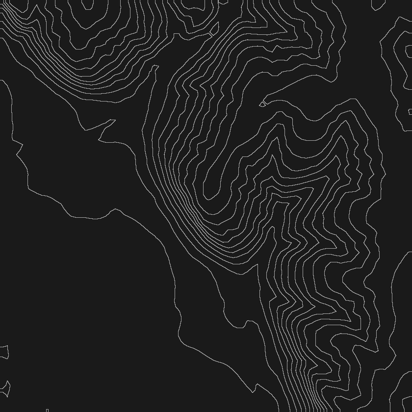
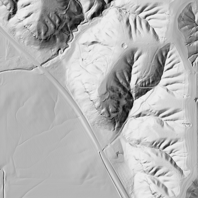
Ordinary contours lose this kind of shelf entirely. With lines plotted at 10-foot elevation steps, a bench with 6 feet of relief sits inside the gap separating two contours and never gets drawn. The map presents an unbroken hillside with no features, while a buck lies on a ledge it cannot display. A quad using 10-foot intervals can portray a steep ridge wall as one uninterrupted incline. Hillshade built from 1-meter LIDAR can instead reveal ledges crossing that very wall. On the shaded relief, those ledges can be simpler to pick out.
Standard topo · 20-ft contours (10m elevation data)
1-meter lidar hillshade · same ground
STEP 5 · THE HONEST OUTPUT IS A ZONE
Narrow your search to four or five places instead of marking a bed
Tell a hunting forum that a good buck appears on your camera only at 2 a.m., and the reply comes back in the same three words: locate his beds. The advice is sound and usually offers little help. Ask the next question, where, and a direct answer never comes. No one can tell you which exact tree shelters him. Someone who places a precise bedding "X" on your map is pretending to know. Deer relocate and winds turn, so the bed a buck chooses can change with the conditions. An honest assessment identifies a search zone rather than a single pin. Reading leeward benches, draw heads, and the protected third of a hill lets you shrink "somewhere on 600 acres" to "four likely shelves and two draw pockets, with that particular spot the probable choice on a north wind." The skill is reducing the search to "4 or 5 key areas" you can scout. Anyone offering greater certainty is selling something that does not exist.
STEP 6 · THE MAP LIES BY OMISSION
The elevation step between contours controls visible detail
The deciding factor throughout is the vertical step between contours. Plenty of quads and app layers place contours at 10 or 20 foot elevation steps. Landforms whose relief falls below that step can be absent. That spacing sets the map's detail limit. A laser measures elevations for LIDAR at 1-meter resolution, arranging them on a grid spaced at 1-meter distances. Where the site allows the beam to reach ground, it can distinguish a ledge rising only a few feet or a lightly cut draw. Shaded relief depicts the ground as though low-angle sunlight swept over a physical terrain model. You can see the shelf directly instead of working it out from gaps between lines. We developed a hunting topo covering the state at 1-meter resolution for this purpose, then added automatic identification of landforms. The system examines terrain and places potential draws, points, saddles, and benches on your parcel map. It produces the four or five scouting areas automatically, with a blind accuracy check controlling release so the marks represent more than shapes added for decoration.
First, you receive a private reading of your own parcel. Your prized hunting spot stays off public forums where someone you don't know would interpret it. The information comes directly to you within your own map, and the reading appears there instead of in a public post. Second, a map cannot be more up to date than the cover it shows. The shape of the land changes at a slow pace; its vegetation changes at a faster pace. Pair the LIDAR reading with recent aerial imagery taken after the leaves have fallen. A bedding shelf with open woods three years ago could be thick with briars today.
A coarse contour interval can leave small landforms worth scouting for deer activity out of sight. Knowing how to read contour turns takes you most of the way. An elevation scan with enough detail supplies the rest while keeping strangers from learning your spot. If your state is within FDR coverage, pull up your own parcel in Scout. Let landform detection identify your four or five main areas to scout on ground that only you can view.
Reading a Bench, Saddle, and Draw on a Topo Map
Landform field checks
NOTES AND SOURCES
- Potential draws, points, saddles, and benches come from interpreting 1-meter LIDAR elevation measurements. A blind accuracy check controls their release. They give you places to begin scouting yourself, without promising deer will use them.
- Beds appear as areas of probability rather than precise spots. Mapping cannot locate a living animal exactly; a pinpoint bedding "X" claims detail that cannot be supported.
- The contour-spacing constraints here apply to conventional topographic mapping with elevation steps of 10 to 20 feet. Comparisons with 1-meter LIDAR use finer renderings of that identical terrain.
- Parcel outlines are based on public county records for the date listed on each parcel and do not constitute a survey.
- Scout is live in all 50 states. Terrain and LIDAR detail varies by location. The material offers no promise of a successful hunt.
Fully Drawn Research is an independent data analysis desk, not affiliated with any state wildlife agency, transportation agency, mapping provider or outfitter. FDR marks candidate landforms and probability zones from LIDAR to focus your own scouting, and does not pin the location of any live animal.
Keep reading
FDR Scout puts research like this on the map of the ground you hunt. Open Scout →