
Reading a Bench, Saddle, and Draw on a Topo Map
A hunter asked a forum to explain how to spot a bench, saddle, or draw on a topo map, and got told to "just walk it." The honest answer is a map-reading skill, but the free contour map baked into most hunting apps is too coarse to show the exact shelves and drainages deer actually use. This guide reads all three features in contour lines, ties each to deer behavior, and shows what a 1-meter LIDAR scan reveals that the standard map erases.
"Can someone point me to a link on how to identify a bench, saddle or draw via a topo map... just giving me 4 or 5 key areas."
He got three replies telling him to get out and walk it, one link to a several-hundred-page government surveying manual, and a couple of "DM me" that went nowhere. That is the whole problem with learning to read terrain: everyone who knows it learned it the slow way and never wrote it down. So here it is written down: what each feature looks like in contour lines, what deer do with it, and why the map most hunters squint at is hiding half of what's on the ground.
- The bend in a contour line carries the information. Lines that point uphill toward higher numbers mark a draw or valley where water collects; lines that point downhill mark a point or spur of high ground. Get that backwards and you'll hunt a dry ridge thinking it's a creek bottom.
- Bench, saddle, and draw each map to a deer decision. A saddle is a travel funnel across a ridge; a draw is a covered travel corridor whose head stacks bedding; a bench is a leeward bedding and staging shelf. Read the shape, and you're reading the movement.
- The standard 10- or 20-foot contour interval destroys the features that matter most. A 3-to-6-foot bench shelf falls between two contour lines and never appears. You see a smooth hillside on the map while a buck is bedded on a shelf the map can't resolve. A 1-meter LIDAR hillshade shows it.
IONE RULE MAKES CONTOURS READ
Every contour line connects points at the same elevation, so a topo map is just a stack of horizontal slices. Lines far apart mean gentle ground; lines packed tight mean steep ground; a closed loop is a hilltop or knob. The whole skill lives in the bend: where lines form a V or U, the direction the point aims tells you the terrain. Point uphill toward higher numbers and you have a draw or valley where water collects; point downhill toward lower numbers and you have a point or spur, a finger of high ground sticking out. Everything below is those bends in different clothes.
IISADDLE · THE TRAVEL FUNNEL
A saddle is the low spot on a ridgeline between two high points: high front, high back, dipped in the middle, like a horse saddle. On the map you're hunting two closed-loop hilltops with an hourglass pinch of contour lines running between them: the lines squeeze together and spread back out, a wasp's waist laid across the ridge. A deer moving from one drainage to the next won't climb the highest point when there's a low, easy gap two hundred yards away, so saddles are travel funnels; bucks especially use them to cross without skylining or burning energy on the steep stuff. The move is to hang on the downwind edge where the two hillsides feed into the pinch.
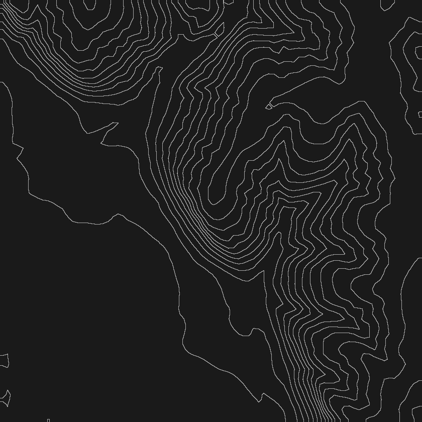
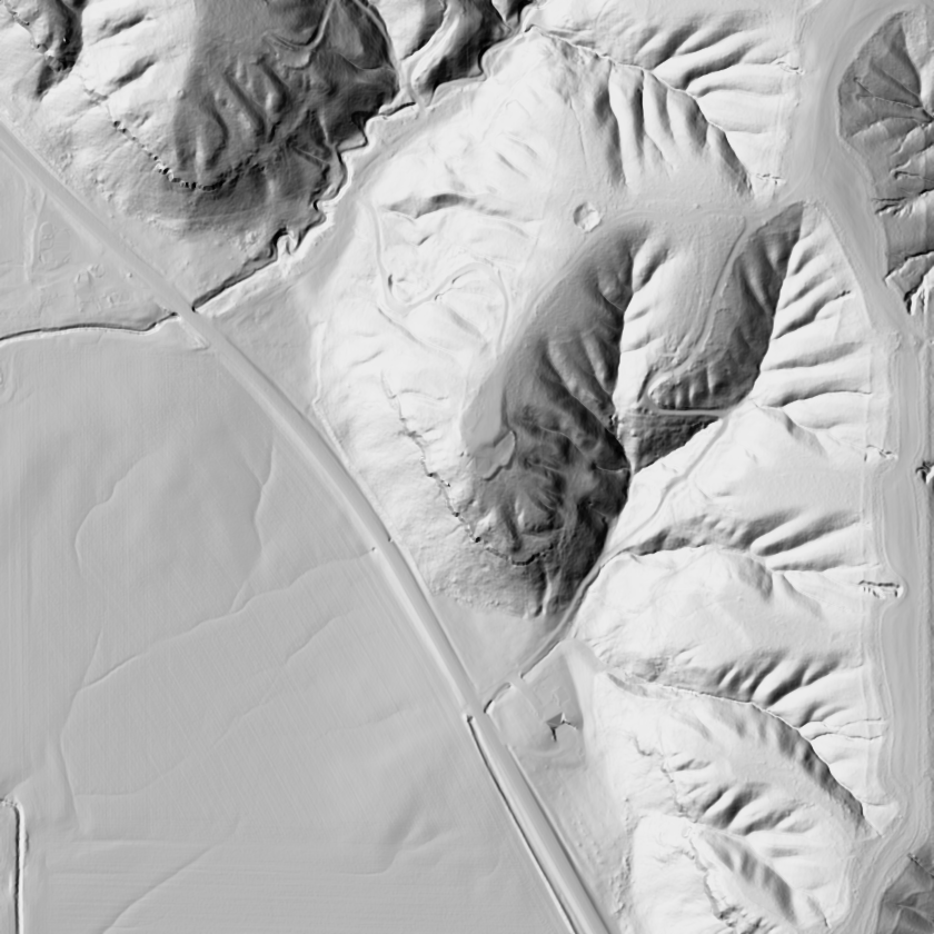
Why the coarse map fails you here: on a standard 10-foot-interval quad, the same wooded ridge shows two rounded hilltops with a vague low area between them and the actual pinch barely readable. Rendered as a 1-meter LIDAR hillshade, the identical ground snaps into sharp 3-D relief; the saddle pops, and a worn benched trail is visible threading dead-center through the gap. That travel route is simply not there on the coarse map. Same dirt, and one version shows you exactly where deer cross.
IIIDRAW · THE CORRIDOR YOU WALK PAST
A draw is a small valley cut into a hillside, a wrinkle where water would run after a hard rain. On the map it's contour lines making a V or U that points uphill toward the higher numbers; the sharper the V, the tighter and more defined the draw. Draws do two jobs at once. They're travel corridors: a low, covered, low-effort route up or down a slope, walked along the bottom or edge below the ridgeline and out of sight. And the heads of draws stack bedding: where a draw pinches out near the top of a slope you get a pocket protected on three sides, with wind and thermals doing predictable things. When two or three draws drain the same hillside into a common bottom, the junction is a collector that funnels deer from a wide area; that junction is a stand site.
The map's blind spot is severe on subtle drainages. On a standard topo, a timbered hillside might show a single shallow contour bend hinting at "some kind of low spot," easy to miss entirely. The 1-meter LIDAR hillshade of that same slope can light up three distinct fingered draws, each with a defined bottom, plus the faint bench where they feed a bedding shelf near the top. The coarse contour interval erased two of the three draws completely; you'd have walked past corridors you never knew were there.
IVBENCH · THE MOST-MISSED FEATURE
A bench is a flat or gently sloped shelf partway up an otherwise steep hillside, a staircase landing: steep up, steep down, flat in the middle. On the topo you're hunting a spot where tightly packed lines suddenly spread apart, a band of open spacing sandwiched between two bands of crowded lines. That gap is your shelf. Benches are bedding and staging real estate: a buck beds with a steep wall at his back so nothing sneaks up from below, wind in his face coming up the slope, and thermals carrying scent from above down to his nose. He sees danger below and smells danger above: a fortress with a view. Mature bucks favor benches on the leeward, downwind third of a hill.
This is exactly the feature a standard map destroys. Draw a contour line every 10 feet and a 6-foot bench falls between two lines, so it never appears. You're looking at a smooth, featureless hillside while a buck is bedded on a shelf the map can't see. The comparison is stark: a 10-foot-interval quad of a steep ridge face reads as one continuous slope with zero benches visible, while the 1-meter LIDAR hillshade of the exact same acre shows two clear shelves cut across the face: a lower one with a matted staging area, an upper one a classic leeward bedding shelf. Same ground; one map shows nothing, the other shows the whole story.
VTHE HONEST OUTPUT IS A ZONE
Ask a forum why a good buck only shows on camera at 2 a.m. and you get the same three words: find his bedding. It's correct and usually useless, because the follow-up (okay, where) never gets a straight answer. Nobody can hand you the exact tree he's under; anyone dropping a precise bedding "X" on your map is faking it. Deer move, wind shifts, and a bed is a decision an animal makes fresh most days. So the honest output isn't a pin; it's a zone. You read the terrain (leeward benches, draw heads, the protected third of a hill) and narrow "somewhere on 600 acres" down to "these four shelves and two draw pockets, and on a north wind, probably that one." That's the actual skill, not a cop-out, and it's the "4 or 5 key areas" that hunter was really asking for. Anyone promising more is selling certainty that doesn't exist.
VITHE MAP LIES BY OMISSION
Everything above hinges on contour interval. The free topo baked into most hunting apps and paper quads draws a line every 10 or 20 feet of elevation, so any feature shorter than that interval (most benches, shallow draws, subtle points, the little shelf a buck actually beds on) simply isn't on the map. It's not wrong; it can't see fine enough. 1-meter LIDAR is a laser elevation scan accurate to roughly a meter: it sees the 3-foot shelf and the shallow draw, and it renders the ground as a hillshade (like raking sunlight across a physical relief model) so a bench doesn't have to be inferred from line spacing, it shows up as a shelf. Fully Drawn Research built its own statewide 1-meter hunt-topo for exactly this, then went a step further: automated landform detection scans the terrain and marks candidate benches, saddles, points, and draws right on your parcel: the four or five key areas, generated automatically and gated behind a blind accuracy check so it isn't just drawing shapes for their own sake.
Two things worth saying plainly. First, the read is on your own parcel, privately; you're not posting your honey hole to a public forum for a stranger to interpret. One hunter did exactly that, screenshotting his spot to ask about a saddle, and a stranger geolocated it from the image and had his location within the hour. The intel comes to you inside your own map; nobody sees your ground. Second, the map is only as current as the cover on it. Terrain changes slowly but the vegetation on it doesn't, so pair the LIDAR read with recent leaf-off aerial imagery; a bedding shelf that was open timber three years ago might be a briar jungle now.
- Lines tight, then loose, then tight across a hillside → bench. A flat shelf on a steep face; bedding and staging.
- Hourglass pinch between two hilltops on a ridge → saddle. A travel funnel; hang the downwind edge of the gap.
- V or U pointing uphill → draw. A travel corridor; check the head for a bedding pocket.
- V or U pointing downhill → point or spur. High-ground travel, with staging on the tip.
- Cross-check every feature on 1-meter LIDAR before you trust it. The coarse map hides roughly half of them.
- Turn each feature into a zone, not a pin. Wind picks the winner on the day.
The through-line: the coarser your map, the more of your best terrain is invisible on it, and the features it erases first (benches, shallow draws, the leeward shelf) are exactly where mature bucks live. Reading contour bends gets you most of the way; a fine-enough elevation scan gets you the rest, without doxxing your spot to strangers. In the states FDR covers, open your own parcel in Scout with Founders access and let the landform detection hand you your four or five key areas on ground only you can see.
- Landform candidates (benches, saddles, points, draws) are terrain reads generated from 1-meter LIDAR elevation data and are starting points for your own scouting, gated behind a blind accuracy check, not guarantees of deer activity.
- Bedding is shown as probability zones, never exact locations; no map can pin a live animal, and any precise bedding "X" is false precision.
- Contour-interval limitations described here refer to standard 10-to-20-foot topographic maps; the 1-meter LIDAR comparisons describe the same ground rendered at finer resolution.
- Parcel boundaries reflect public county records as of the date shown on each parcel and are not a survey.
- Terrain and LIDAR layers are available in the states FDR currently covers, with Illinois and Wisconsin live and more of the Midwest rolling out through 2026; nothing here guarantees hunting success.
Fully Drawn Research is an independent data analysis desk, not affiliated with the Illinois Department of Natural Resources, the Illinois Department of Transportation, or any mapping or outfitting provider. FDR marks candidate landforms and probability zones from LIDAR to focus your own scouting, and does not pin the location of any live animal.